

WYNBERG
Province/state: Cape Province/Cape Colony; now Western Cape.
Division: Cape.
Magisterial district: Wynberg.
Additions: –
Incorporated: 1927, into Cape Town.
The arms may be blazoned:
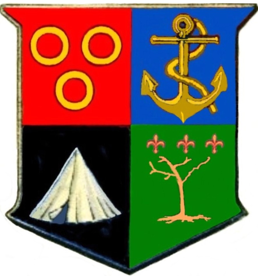
Arms: Quarterly: I: Gules, three annulets or; II: Azure, an anchor or; III: Sable, a bell tent proper; IV: Vert, a vine bearing three fleurs de lys in chief, all or.
About the arms:
The first quarter repeats the arms of Van Riebeeck. Jan van Riebeeck, founder of the Cape Colony, was also the first farmer at Wynberg.
The second quarter brings in the anchor, symbolic of hope and associated with the figure of Hope, seen as the crest in the arms of the Cape Colony and the dexter supporter in the arms of Cape Town.
The tent in the third quarter represents the military camp on Wynberg Hill, which was first used in 1809 and is still an important military base.
The vine in the fourth quarter is a symbol of the wine industry, first established in this area of the Cape Colony in the time of Van Riebeeck and today still in limited production (further south, in the Constantia valley), although the major area of production had shifted by the late 17th century to the Boland.
The fleurs de lys represent the French refugees of 1688, known today as Huguenots, some of whom were specifically recruited for their knowledge of wine-making and brandy distillation. Their main influence was in the Boland, but their skills were also used in Wynberg.
About the town: The Commander’s farm was at this stage the southernmost outpost of the infant colony, and the hedge of wild almond (Brabejum stellatifolium) that Van Riebeeck had planted along the colony's boundary (largely following the Liesbeeck) went around the farm. However, the name Wijnberg later shifted to properties further down the hill (on the southern side), and the Commander’s farm became known as Boschheuvel. Honoratus Maynier bought the property in 1805 and called it Protea. It was again occupied by the colony’s head of government when Sir Lowry Cole (Governor from 1828 to ’33) purchased it. In 1848 Sir Lowry leased the property to Bishop Robert Gray, first Anglican Bishop of Cape Town, and in 1851 sold it to the Colonial Bishoprics Fund, at which point the property formally became known as Bishop’s Court. In later years much of the Boschheuvel/Protea/Bishop’s Court property was sold off, becoming a select residential area known as Bishopscourt (written as one word), but the house originally built by Van Riebeeck and extended down the years is still the official home of the Archbishop of Cape Town and retains fairly large grounds. The Dutch East India Company, or VOC, had a military camp known as Wijnberg. Maps made in 1780 and 1796 show that this was situated on the plain in the area now called Plumstead, where a village began forming around 1826. However, the British did not use this camp, instead concentrating its forces at the Castle. When troops were moved into the countryside in 1800, the site used was the Camp Ground in Rondebosch (today Rondebosch Common). The Batavian Republic (1803-06) also used the Camp Ground, and when the British re-occupied the Cape in 1806 they again used the Camp Ground. In 1809 the government acquired land in Wynberg from Alexander Tennant, so beginning the present-day military camp. Sir Richard Bourke, Acting Governor 1826-28, recommended that part of the Wynberg military camp be sold off in building lots. Land was also granted to the Nederduitsche Gereformeerde Kerk in 1832 and to the Anglican church of St John in 1836. The NG Kerk building was first erected in 1839. It was extensively altered in 1889 and was proclaimed a historical monument in 1965. A large part of the village that grew up around the two churches was laid out on the property Klein Oude Wijnberg, a subdivision of the farm Oude Wijnberg which was first occupied in the early days of the Cape settlement. Prosperous Capetonians began building country villas in Wynberg, and British officials on leave from India favoured the village as a holiday resort. By 1840 more than 100 visitors were living in or near Wynberg, mostly in the village of Kenilworth. By 1850 the influx of Indian visitors was checked by the Indian Mutiny, by faster transport links with the Indian subcontinent, and the attractions of Australia. The second railway in the colony was built from the junction at Salt River to Wynberg in 1862. The railway station was built some distance from the village, and a new area opened up in the vicinity of the station, known informally as Plumstead. However, when the railway was extended southwards the name Plumstead was given formally to a railway halt south of Wynberg station, and eventually became a large suburb in its own right. Wynberg in fact eventually had four railway stations: Kenilworth, Wynberg, Wittebome and Plumstead. (Wittebome takes its name from the proteaceous Leucadendron argenteum, or silver tree – called witteboom in Dutch, but more usually silwerboom in Afrikaans – which was once common on Wynberg Hill.) Wynberg became neglected following the events of 1850, but in 1886 the authorities decided to built extensive barracks and other military works at the camp, and the village revived. The first local municipality was created in 1883 under the name of Liesbeek, and comprised five wards: Mowbray, Rondebosch, Newlands, Claremont and Wynberg. In 1886 Liesbeek was broken up into the municipalities of Rondebosch, Claremont and Wynberg. The town of Wynberg was progressive, and eventually built three reservoirs on the Back Table: the Victoria, Alexandra and De Villiers reservoirs. These were complemented by two reservoirs that Cape Town built slightly further north on the Back Table, the Woodhead and Hely-Hutchinson reservoirs. All five are still in use. The Back Table is also the site of the world’s largest sandstone cave system, the extent of which only became clear in the second half of the 20th century. The military camp became less important following the South African War, but following the formation of the Union Defence Force in 1913 it again became a major centre of military activity. The town of Wynberg boasted an extensive public open space in Wynberg Park, 38 ha of parkland and forest. Between the commercial area of the town (the original “Plumstead”) and the old village lies Maynardville, also a large public park, which has an open-air theatre and since 1956 has hosted an annual Shakespearean festival. The town of Wynberg (including Kenilworth and Plumstead) became part of Cape Town in 1927. Around 1954 the architect Brian (Sonny) Heseltine began the restoration of the old village of Wynberg, which contained some fine examples of Regency architecture. He renovated several dwellings in Durban and Victoria roads, and others have since renovated more cottages. The Standard Encyclopædia of Southern Africa reports: “Through their combined efforts Old Wynberg was renewed as an æsthetic, architectural and cultural entity – ‘Little Chelsea’ – that is unique in South Africa.” Wynberg Village was designated as a conservation area in 1981. Name of the town:
The name Wijnberg1 (“wine-mountain”) was first used in 1658 when Jan van Riebeeck, having been forced to abandon his farm on the windswept open space that later became Green Point Common, occupied the hilltop overlooking the source of the Liesbeeck River, below the Back Table of Table Mountain, and planted a vineyard there.
Although in Dutch the name is pronounced as Veen-berrg, in Afrikaans it is Vane-berrg. The English form retains the idea of wine that has been there since Van Riebeeck’s time: Wine-buhg.
Magisterial district:
The town of Wynberg was also (and the suburb still is) the seat of the magisterial district of Wynberg, which is considerably larger than the former municipality. It reaches the Atlantic coast, and so includes Hout Bay and Llandudno, and includes the municipalities (merged with Cape Town in 1913) of Mowbray, Rondebosch and Claremont, as well as the Constantia and Tokai areas south of Wynberg and most of the Cape Flats.
1 In Dutch the name is spelt with the IJ ligature. However, in Afrikaans this becomes the letter Y. Although in many respects South African English orthography follows Dutch forms rather than Afrikaans, in this instance the Afrikaans spelling is favoured.

Vir Afrikaans, kliek hier
Comments, queries: Mike Oettle