

RONDEBOSCH
Province/state: Cape Province (previously Cape Colony, since 1994, Western Cape)
Division: Cape
Magisterial district: Wynberg.
Incorporated into: Cape Town (1913)
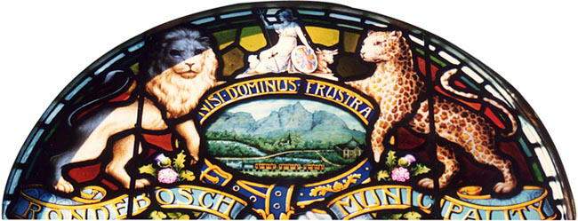
The arms as illustrated are, heraldically speaking, very poor. They do not appear to have been registered. They form a stained glass window in the Rondebosch Town Hall, a building which is still in use, although today it is a branch of the Cape Town City Libraries, rather than a civic hall.
About the arms:
The central device is a landscape drawing enclosed in a horizontal oval by a garter (in imitation of the blue garter in the British royal arms).
The landscape comprises an accurate depiction of Table Mountain and Devil’s Peak with a fanciful middle and foreground. (Table Mountain can also be seen in the arms of the Western Cape, while a slightly different perspective on Devil’s Peak can be found in the arms of Westerford High School.)
In the middle ground is a forest in which can be seen St Paul’s (Anglican) church, reputedly built on the site of the Ronde Doorn Bosje (see below).
Below the forest is the north-south Main Road that links the southern suburbs of Cape Town (originally the very first wagon road in the colony) crossing the Liesbeek River on a bridge and intersecting with the eastward road into lower Rondebosch. (In reality the bridge lies a couple of kilometres upriver, at Westerford.)
At right is the Town Hall with a dome that was in fact never added to the structure. (The building actually stands on the right bank of the river, not the left bank as shown.) In the foreground is the steam train that ran to Wynberg on the railway built in 1862 – one of the first in the colony (and which remains a vital commuter route).
The town of Rondebosch had, until 1890, four railway stations: Observatory (on the boundary with Woodstock), Mowbray, Rosebank and Rondebosch. After 1890, Mowbray and Observatory stations were outside the municipality.
The garter is inscribed with the motto Nisi dominus frustra. This translates as “Without the Lord all is in vain” – incidentally also one of the two mottoes of the (Dutch) Reformed Church in America.
The crest is the symbolic figure of Britannia, wearing a crested helmet, holding an oval shield of the British Union Flag (so-called Union Jack) and a trident. She is flanked by a sheep (dexter) and a cow (sinister). Britannia symbolises the overwhelmingly British character of Rondebosch in the late 19th century, despite its Dutch origins, and the livestock stand for the town’s agricultural beginnings.
The supporters, a lion (Leo leo, dexter) and a (natural) leopard (Leo pardus, sinister), depict wildlife once found in the vicinity. They stand on a scroll inscribed “Rondebosch Municipality” and between their feet are floral emblems, (pink) thistles for Scotland, shamrocks for Ireland and pink roses (presumably in error, since they probably are intended to be the Tudor rose of England, combining red and white in a single blossom).
About the village:
Rondebosch’s origins are closely tied with the early history of the Cape Colony. Attempts at agriculture close to the fort in Table Bay – in the Table Valley and on the seaward side of Signal Hill – were frustrated by the strong south-easterly and north-westerly winds.
In 1656, four years after the Dutch settlement had begun, land was ploughed along the Liesbeek River (at this stage called the Amstel or Versse Rivier) and experimental crops of wheat and oats sowed.
Following the success of the experiment, Commander Jan van Riebeeck ordered that the round thorn grove, or Ronde Doorn Bosje, a landmark along the wagon road that had formed along the Liesbeek’s left bank, be levelled inside and converted into a kraal or used as a redoubt.
On 10 August 1657, seven employees of the Dutch East India Company (Vereenigde Oostindische Compagnie) were created free burghers and (on 12 August) granted land along the Liesbeeck. A group of free burghers led by Steven Botma settled near the Ronde Doorn Bosje and were known as the Stevens Colonie.
In 1957 Rondebosch celebrated the tercentenary of its foundation of the first settlement of free burghers in Southern Africa.
Rustenburg:
In the same year, 1657, a house of burnt brick was built for the head gardener of the VOC’s garden in Rondebosch, only about 200 m north of the Bosje. It faced the wagon road that is now Main Road, Rondebosch. In 1670 the house was enlarged to form a country residence for Commander Pieter Hackius, who named
the house Rustenburg (place of rest) and who died there in 1671. “The Commanders and Governors of the Cape used Rustenburg as a holiday home in the summer, when their quarters in the Castle became unbearably hot.” This continued until 1751, when Governor Ryk Tulbagh built a house on the VOC’s farm de Nieuwe Landen (now called Newlands House), and left Rustenburg for the use of the Secunde or important guests.
A summerhouse was built at the top of the property in 1760. (Now the property of the University of Cape Town, this was proclaimed a national monument in 1960.)
The house had an upper storey added around 1780, with a flat roof and a dakkamer (attic), and four pilasters were added to the façade.
The bankruptcy of the VOC in 1792 forced the sale of most of its houses, but Rustenburg was in poor repair, and remained in company hands. In 1795 it was where the terms of capitulation were signed, and subsequently passed into the hands of the British government. But although it was the home of the military commander, General Dundas, from 1798 to 1801, it was not again the home of governors. It was sold in 1803 to Johannes Hoets, who appears to have added the four large columns in front.
A school for girls was begun in the house in the late 18th century, but as it grew it acquired larger premises. Today Rustenburg Girls’ High School is a couple of kilometres away, close to Rondebosch Common, while Rustenburg Girls’ Primary School occupies the grounds of Rustenburg House. The house itself, proclaimed a historical monument in 1941, is used as a school art centre.
Groote Schuur and Westbrooke:
Two other houses in Rondebosch have played a significant role in the area’s history: De Schuur, now Groote Schuur; and De Onder Schuur, later Westbrooke and now called Genadendal. Both these houses lie upward toward the mountain (west) from St Paul’s church.
The VOC established a granary in 1657 which became known as De Schuur (The Barn) or De Coorenschuur (The Granary). This building, which incorporated the home of the Master of the Granary, was sold in 1791. It changed hands frequently. In 1812 the name was changed to De Groote Schuur, and a second barn was altered into a dwelling-house, now called De Onder Schuur. In 1832 Mr Justice William Westbrooke Burton bought De Onder Schuur and gave it his second name. Successive governors occupied it as tenants to the end of the century. A widow who bought Groote Schuur in 1879 changed its name to The Grange.
In 1891 Cecil John Rhodes bought The Grange, and began buying back all the small parcels of land sold off from the property that had once belonged to it, including Westbrooke, and in addition buying a further 600 hectares – making it an extensive estate incorporating a large part of the mountainside. He restored the name Groote Schuur, but kept the name Westbrooke. The house Groote Schuur had been rebuilt several times in the past, but in 1896 was destroyed by fire, and Rhodes commissioned Sir Herbert Baker to restore it. Baker, not knowing its original form, rebuilt it according to one of its later styles as a double-storeyed residence.
In his will Rhodes bequeathed the entire Groote Schuur estate to a “federal” South African state which had yet to come into being. From 1910 until ’84, when the office was abolished, the house Groote Schuur was the home of all South Africa’s Prime Ministers. Westbrooke served as the residence of the Governors-General from 1910 to ’61, and continued as a presidential residence until President P W Botha decided to remain in Groote Schuur. (Botha also had the Garden House, a gubernatorial/presidential residence adjoining Parliament in Cape Town [known as Government House up to 1961], refurbished as Tuynhuis, and used that as his primary residence and place of work at the Cape.) Groote Schuur later became a museum.
Since 1994 Westbrooke (which was named Genadendal in ’95) has again been the presidential residence in Rondebosch.
During the 1920s the University of Cape Town established a new campus (still the university’s main campus) on the Groote Schuur Estate above Rondebosch and Rosebank.
Rondebosch and Mowbray:
Rondebosch and Mowbray share an extensive piece of open land, now called Rondebosch Common, which in 1800 became the military Camp Ground. The Camp Ground was abandoned when the military camp at Wynberg was established in 1809. The military function is recalled in Campground Road, which runs north-south along its western side and, starting in Mowbray, runs through Rondebosch and Newlands, intersecting the Main Road in Claremont where it links up with Protea Road, originally a branch of the wagon road that led to Jan van Riebeeck’s farm (see Wynberg).
The first local municipality was created in 1883 under the name of Liesbeek, and comprised five wards: Rondebosch, Mowbray, Newlands, Claremont and Wynberg.
In 1886 Liesbeek was broken up into the municipalities of Rondebosch, Claremont and Wynberg. R M Ross became the first mayor of Rondebosch, which at that stage included Rosebank and Mowbray.
A cast-iron fountain was erected at the road junction below St Paul’s Church in 1891. It was proclaimed a historical monument in 1964.
Mowbray became a separate municipality in 1890. Rosebank remained part of the Rondebosch Municipality until 1913, when Rondebosch and Rosebank became separate suburbs of Cape Town.

Vir Afrikaans, kliek hier
Comments, queries: Mike Oettle