

CAPE TOWN / KAAPSTAD / IKAPA
Province/state: Western Cape (until 1994, Cape Province/Cape Colony).
Division: Cape.
Additions: 1913 Claremont, Green and Sea Point, Kalk Bay, Maitland, Mowbray, Rondebosch, Woodstock; 1927 Wynberg.
Incorporated: 1995, into Greater Cape Town Metropolitan Council.
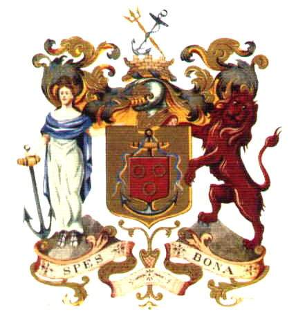
The arms, granted by the College of Arms on 29 December 1899, may be blazoned:
Arms: Or, an anchor proper decorated with a ribbon azure; an inescutcheon gules charged with three annulets or, 2 and 1.
Crest: Upon a short tower of pale yellow stone, masoned sable, an anchor proper in bend sinister and a trident or in bend.
Wreath and mantling: Or and azure.
Supporters and compartment: Dexter the symbolic figure of Hope, being a woman proper vested argent draped azure and shod with sandals, holding with her dexter hand an anchor proper, standing upon a representation of Devil’s Peak; and sinister a lion gules, standing upon a representation of Lion’s Head.
Motto: Spes Bona.
Arms of 1804 and 1899: Advocate De Mist was not permanently appointed to the Cape, being an official whose job was to examine the system of government of the Dutch colony – which the revolutionary republican régime had inherited from the bankrupt Dutch East India Company – and recommend reforms. However, he discovered so much that needed his attention that he remained for the duration of the three years before Britain again captured the Cape. As a representative of a revolutionary régime which had, in the Netherlands, abolished heraldry altogether, it was a bold step for De Mist not merely to tolerate the use of coat-armour, but to grant arms not only to Cape Town (the Raad der Gemeente Kaapstad) but also to each of the five drostdijen, or district seats, in the country districts. All six of these coats of arms used an anchor as a single supporter, and displayed on its shield the arms associated with the town’s founder or namesake. For Cape Town he chose the arms of the Van Riebeeck family – although Jan van Riebeeck, the founder of the settlement, did not personally bear arms, but his mediæval ancestors did. (Van Riebeeck’s home town was Culemborg, in Gelderland province.) However these elegant and simple arms may be blazoned Gules, three annulets or, 2 and 1. The arms were presented to the council in the council chamber of the Stadhuijs2 (or Town House) on 3 July 1804. He explained the arms saying: “The anchor symbolising Good Hope as well as the gold foundation on which this anchor rests, indicate my wish for the future wealth and prosperity of this settlement; the same is covered and protected by a red shield, bearing three golden rings,3 being the coat of arms which we know was borne by your father and founder, Van Riebeeck.” The original seal of the community council set up in 1804 (with the wording “Zegel van de Kaapstad”) was still in use as late as the 1950s, with the addition around the outer edge of the English wording “The Council of the City of Cape Town”. In this form it was officially registered in 1956. The arms as illustrated above were granted by the College of Arms on 29 December 1899, following the discovery by the Governor that they had not been granted by a British heraldic authority. The heralds in London clearly either did not understand that the anchor was a supporter, or ignored this fact in the light of British heraldic tradition, which normally does not tolerate single supporters. As a result the anchor was vaguely associated with the shield (now an inescutcheon) by means of a blue ribbon that does not actually suspend the shield from the anchor. The whole was placed on a gold shield. The crest has at its base a tower symbolising the Castle of Good Hope, a pentagonal stone fort with bastions in the Renaissance style, but not imitating its shape. (The Castle does figure in later symbolism, both heraldic and non-heraldic.) Crossed above the tower are an anchor and a trident – the anchor being a recurring theme in Cape heraldry, and here symbolising the safe harbour of Table Bay, recently (in 1899) made safer by the construction of the Alfred and Victoria Basins. These relatively small harbour works (compared with the Duncan Dock, constructed following the Second World War, and further enclosures of the sea in the late 20th century) today form the Victoria and Alfred Waterfront, a historic precinct incorporating a variety of shops, hotels, tourist excursions (such as boat trips to Robben Island), a marine aquarium of international standing, a real ale brewery and outpost campuses of both the University of Cape Town (the Graduate School of Business, housed in the Breakwater Prison) and the Cape Technikon. The trident is a symbol of Neptune, the Roman god of the sea – or his Greek equivalent Poseidon, who was also god of earthquakes – and is most likely intended to represent the Atlantic Ocean in its various roles as international trade route, source of the immense variety of fish and other edible marine life for which Cape Town is renowned, as well as the terrifying gales and storms for which Table Bay is also known. The dexter supporter is the symbolic figure of Hope, apparently taken from the crest of the Cape Colony. She is dressed in the traditional white dress and blue mantle, and holds the anchor (in this coat of arms, the third anchor!) which identifies her as a symbol of hope. The sinister supporter is a red lion, in its colouring imitating the lion of Scotland, but it could conceivably also represent the lions of England, of the Principality of Wales, and of the various provinces of the Netherlands. Wild lions (Leo leo) were also to be found in the vicinity of Cape Town when Table Bay was first settled. The compartment the supporters stand on is a curiously Victorian concoction, resembling in part a gas bracket, yet incorporating not the whole of Table Mountain, but only Devil’s Peak and Lion’s Head, the two peaks that flank the main mountain massif as seen from Table Bay. A stylised view of the entire mountain can be seen as the compartment in the arms of the Western Cape Province, while the eastern face can be seen in the arms of Rondebosch. The motto, Spes Bona, translates as “Good Hope”, and is not merely an allusion to the name of the promontory at the southern end of the Cape Peninsula, but also the continuation of a tradition of very long standing. The wording was first used heraldically in the arms of the South African College (now the University of Cape Town and the SA College Schools in Newlands), and is found also in the arms of the Cape Colony, the Cape Province and the Western Cape Province. However, the tradition goes right back to the 17th century. The early settlement: In 1620 two Englishmen, Andrew Shillinge and Humphrey Fitzherbert, hoisted the English flag over the bay, but their annexation was not acknowledged by King James I. Already in 1617 Dutch fleets headed for the Spice Islands had been ordered to sail due east from their rounding of the Cape of Good Hope, and to turn northwards from a point south of the Sunda Straits. This rendered Mauritius and other potential revictualling stations unsuitable. A favourable report on the bay was submitted by the survivors of the wreck of the Nieuw Haerlem, who had lived on its shores from March 1647 until April the following year. The return fleet of 1648, which picked them up, managed to purchase vast numbers of cattle from the local Khoikhoi, was was a crucial factor, since supplies of meat and vegetables had begun diminishing on St Helena. The English also laid more definite claim to St Helena in 1651. Jan Antonisz van Riebeeck, a ship’s surgeon who had been disciplined by the Dutch East India Company (Vereenigde Oostindische Compagnie, or VOC) for private trading, was given a chance to redeem himself and was made opperhoofd (chief) of a refreshment station to be established in Table Bay. (He was later promoted to commander.) His fleet comprised the Dromedaris, the Reijger and the Goede Hoop, which sighted Table Mountain on 5 April 1652 and dropped anchor on the evening of the 6th, and the Walvis and the Oliphant, which arrived only on 7 May. Van Riebeeck himself went ashore on the 7th and the following day demarcated a site for a fort. The women and children went ashore on the 24th and occupied wooden huts which had been erected. On 15 May the wooden fort was named Goede Hoope, and its four buttresses were named after the other ships of the fleet. Ziekentrooster (sick comforter) Willem Wijlant and his wife were the first to occupy the half-built fort on 4 June, and two days later their son Bernert was born there, the first Christian born at the Cape. The fort served for some three decades, but in 1664 a decision was taken to replace it with a stone-built fortification in the Renaissance style with five buttresses, which was later called the Castle of Good Hope (Kasteel de Goede Hoop). Its site was laid out 60 Rhineland roods (227 m) south-east of the fort, and construction began in 1665. Two years later, work was suspended because hostilities with England had been halted. Construction resumed in 1672, and the building (in its original form) was completed in 1679. The Castle’s five buttresses were named after titles held by the Prince of Orange: Buren, Catzenellenbogen, Nassau, Oranje and Leerdam.5 Municipal government: Under the rule of the VOC the town had been entirely under the control of the Governor (or Commander) and the Raad van Politie (Council of Policy). The Batavian Republic renamed the Burgher Senate, retaining its members but calling it the Raad der Gemeente (community council). In 1805 the council was also given charge of putting out fires and the care of the aged and poor. In 1806 the name Burgher Senate was revived, and in 1814 a proclamation standardised the taxes which this body might levy. However in 1827 the Senate was dissolved, and for 12 years the town was ruled by the central government, local taxes being diverted to the Treasury. In 1836 the colony’s Legislative Council passed the Municipal Ordinance, but Cape Town was excluded from its provisions. Only in 1839 was a further ordinance passed (amended the following year) constituting the Municipality of Cape Town, excluding Green and Sea Point on the one side, and Woodstock on the other. In 1861 a Municipal Board of 12 commissioners and 24 wardmasters was created, with powers greatly increased over those of 1840. In 1867 the board was abolished and replaced by a Town Council of 18 members, three being elected by each of the six districts into which the city was divided. The Atlantic seaside resorts of Green Point and Sea Point were joined as a municipality separate from Cape Town, called Green and Sea Point, in 1839. The municipality was reconstituted in 1859, and became part of Cape Town in 1913. Rondebosch was also amalgamated with Cape Town in 1913. Claremont became a municipality in 1886 (incorporating Newlands). The town had three railway stations on the line to Wynberg: Newlands, Claremont and Harfield Road, all of them still in use. The town was amalgamated with Cape Town in 1913. Kalk Bay, 27 km from Cape Town on the road to Simonstown, was named for the limestone (kalk) kilns set up there in the 17th century. A small military outpost at Kalk Bay was captured by the British in 1795 during their advance on Muizenberg, where the major engagement of the British landing was fought. A fishing and whaling village grew up in the bay between 1806 and 1811, and in the 1860s it became popular as South Africa’s first seaside resort. Afer 1872 the fishing population was increased by a number of Filipino immigrants. Further growth came when the railway line to Wynberg was extended to Fish Hoek, with stations at Muizenberg, St James and Kalk Bay. In 1893 Kalk Bay and Muizenberg became a separate municipality, called Kalk Bay, which was amalgamated with Cape Town in 1913. Maitland became a town in 1903. It was amalgamated with Cape Town in 1913. The town of Wynberg held out on its own until 1927, when it also joined Cape Town. In 1995 the cities of Cape Town and Bellville, the Cape Divisional Council and the towns of Pinelands, Milnerton, Goodwood, Parow, Durbanville, Kuils River, Somerset West, Strand, Gordon’s Bay, Fish Hoek and Simon’s Town were combined to form the Greater Cape Town Metropolitan Council. Within the structure of the metropolitan council its area was then subdivided into the municipalities of Cape Town, Tygerberg and South Peninsula, the Cape Town Municipality comprising areas on the eastern, northern and western sides of Table Mountain as far south as Wynberg. Magisterial districts and city status: The 1913 incorporations not only made it a city, but extended it into the magisterial districts of Wynberg and Simon’s Town. (Kalk Bay and Muizenberg still fall under the magistrate at Simon’s Town.) In 1867 Cape Town was officially proclaimed a city, but in terms of the usage of the time it had already become a cathedral city on 20 February 1848 when Robert Gray, first Anglican Bishop of Cape Town, landed. The old St George’s Church in Wale Street (officially opened in 1834) then officially became a cathedral, and Bishop Gray attended the service there that evening (it was a Sunday). At the end of the 19th century Sir Herbert Baker was asked to design a new building (on the same site) in the French Gothic style, and in 1901 the Duke of Cornwall and York (later King George V) laid the foundation stone. The first part was completed in 1913, and the two transepts were completed in 1957. Further building continued into the 1980s. Already in 1838 a Roman Catholic bishop had arrived in Cape Town, but the Roman Church did not have the status of a State Church, so the presence of a Roman bishop did not count in terms of the city’s status. Names of the city: The earliest European name on record is a reference to the mesa (or table) which the Portuguese admiral Antonio de Saldanha6 climbed in September 1503, so becoming the first European to see the entire Cape Peninsula and False Bay7 from this vantage point. Saldanha was himself wounded later that same day in an altercation with Khoikhoi. A few years later, on 1 March 1510, Francisco de Almeida, Viceroy of India, was killed in a similar altercation at the mouth of the Salt River. As a result the Portuguese subsequently avoided the bay with its reliable water source, which in later years they called the Aguada (watering place) de Saldanha. In 1601 the Dutch explorer Joris van Spilbergen first referred to the mountain as Tafel Berg and the bay Tafel Baaij, and in Dutch usage the names stuck. He also transferred the name Saldanha to the southern inlet at the Cape Columbine peninsula. Not only the Portuguese but also the English continued to use the name Saldanha for Table Bay, English records referring to it as “Saldanhia” or “Soldania”. The earliest name of the settlement in Table Bay was the Portuguese “Cabo” – in full, “Cabo de Goede Hoop” (a half-translation of Cabo de Bõa Esperança), which was reduced to “Caab” and later spelt in Dutch as “Kaap”. It was referred to as “het Vlek van de Caab” or the “Caabsche Vlek” (Cape hamlet). By the middle of the 18th century English-speaking visitors were referring to the town as Cape Town, and it was known among its inhabitants as Kaapstad. The name Cape Town was used officially from 1795 to 1803, and was again in use from 1806. De Mist proposed a change of name to Van Riebeeck Stad, but there was little enthusiasm for this. Despite the community’s growth to city status, which it attained in 1867, it has retained the names Cape Town and Kaapstad. Prior to 1995 municipal vehicles, uniforms and badges bore the legend CCC (Cape City Council), but “Cape” was here seen as shorthand for “Cape Town”. The name Ikapa is listed at the top of this page, but although Xhosa-speakers make up a sizeable minority in the city and have known it by this name for at least a century and a half, this was not an official name of the city until 1994. And already in 1995 it had been absorbed into the Greater Cape Town Metropolitan Council. “Ikapa” is simply an adaptation of “Kaap” in isiNguni. The Xhosa-speaking people, before they were incorporated into the Cape Colony, were never closer than 900 km away from Table Bay. (For information about this ethnic group, see Ciskei and Transkei.) The city has never officially been called the Mother City, but this is perhaps its most popular nickname, of which there are several more.
The arms illustrated are a Victorian elaboration of a strikingly simple and effective coat of arms, originally granted to the town of Cape Town on 12 June 1804 by the Batavian Republic’s1 Commissioner-General at the Cape, Jacob Abraham Uitenhage de Mist.
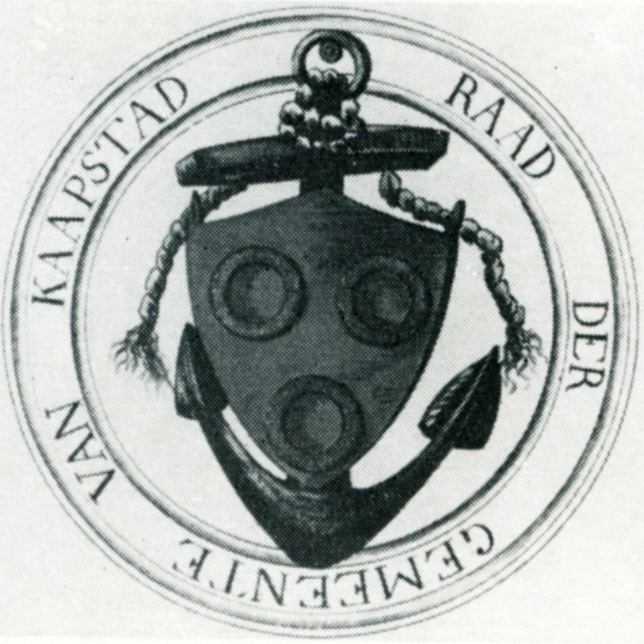
Table Bay, and in particular the Varsche (Fresh) River4 running down from the mountain, was well known long before any permanent settlement was established at the Cape.
Municipal government at the Cape began only in 1796, when the British authorities created a Burgher Senate, comprising six members appointed by the government. Their duties included the care of streets, advice on rates and taxes, prices of foodstuffs, wages of artisans, suppression of nuisances, and ensuring fuel supplies.
Until 1913 Cape Town was merely the largest of a number of towns in the magisterial district of the same name.
The earliest names recorded for the area around Cape Town are Khoikhoi names. But these transhumant cattle herders do not appear to have a fixed name for the area, since the mountain now known as Table Mountain was referred to as either Goerikamma (mountain by the great water) or Ghutais (veiled by the clouds).
