
DE AAR
Province/state: Northern Cape (previously
Cape Province/Cape Colony).
Division: De Aar.
Additions: Burgerville (1936).
Incorporated: into Emthajeni Municipality, part of the Karoo District Municipality.

The arms may be blazoned:
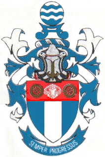
Arms: Azure, a pale argent; upon a chief gules, a ram’s head caboshed argent between two spoked railway wheels or.
Crest: Upon a wreath argent and azure, a water budget azure surmounted of a fountain.
Motto: Semper progressus.
About the arms:
Almost every part of this device alludes to the town’s importance as a railway junction, and to the water available there which was indispensable to the operation of steam railways.
The silver pale would seem to be a reference both to the railway line, linking Cape Town to Gauteng, and the reputed underground river which gave its name to the town.
The wheels are clearly railway wheels, typical of those used on both passenger coaches and goods trucks of the Cape Government Railways.
The ram’s head is that of a merino sheep, and represents the wool and mutton production that is the mainstay of the district’s farmers – indeed, it is typical of much of the Great Karoo. See here for a discussion of this industry.
The water budget (a charge derived from a yoke on which a pair of leather water sacks was carried) and the fountain (a roundel barry wavy argent and azure, the conventional symbol for a water source) in the crest both allude to water. The water budget may refer to the water obtained from Burgerville, or to the necessity of carrying water on trains, both for steam generation and to slake the thirst of passengers in the Karoo.[1]
About the town:
The name De Aar was given to a property first surveyed in September 1837, and subdivided in 1839. The subdivision,
purchased by Jan Gabriël Vermeulen, was named (“de aar” is Dutch for “the vein”) for a strong perennial spring there.
Surveys carried out in 1881 identified this piece of land as suitable for the primary junction for interior railways on the Cape Government Railways system.
It was initially named Brounger Junction, after William George Brounger, chief engineer of the CGR and the prime architect of the system’s growth from the time he arrived in Cape Town on 31 October 1857 until his retirement.
The line from Beaufort West, aimed to connect Cape Town, Port Elizabeth and East London to Kimberley, reached De Aar in November 1883, and just a month later it had been pushed as far as the Orange River (where there was a delay pending the construction of a bridge over the river). The section from Beaufort West to De Aar measures 259 km.
However, local pressure among Karoo farmers and politicians was too strong for the name Brounger Junction to last, and for most of the past 120 years the name on the station platforms has been DE AAR.
Sadly, the town has no monument to Brounger, whose involvement in the colony’s railways began with the initial survey upon which the construction of the Cape Town-to-Wellington railway (work started 1858; line opened in 1861) was based.
When the race to Kimberley was first mooted in 1871, Brounger was placed in charge of the lines running from the three ports (from this point officially named Cape Western, Cape Midlands and Cape Eastern), their conversion from 4ft 8½in gauge to what
would now be the standard 3ft 6in (1 065 mm, known as “Cape gauge”), and their extension into the interior.
The Cape Midlands line linking Port Elizabeth to Alicedale,[2] Cookhouse, Cradock, Middelburg Road and Colesberg was completed in 1883, and in the same year work was begun on a line linking Naauwpoort, 60km south of Colesberg, to De Aar; this was opened to public traffic on 31 March 1884.
It was not too long before East London, too, was linked to De Aar by means of a line connecting the Cape Eastern and Cape Midlands systems, between Stormberg Junction and Middelburg Road (which was later named Rosmead).
Brounger had been put in charge of the Cape Western System in 1880, when a general manager was appointed for the three systems.
De Aar is 806 km (501 miles) from Cape Town and 801 km (498 miles) from Pretoria. In addition to being the central point for the railway lines running from the three Cape ports, it was also linked to South West Africa following the First World War.
In 1902 the brothers Isaac and Wolf Friedlander, who owned a shop and a hotel at the station, bought the farm De Aar for £11 000 and subdivided it, providing land for churches, a town hall and sports fields. Residential and commercial erven (plots) were sold by auction in December that year, and on 20 May 1904 the town was declared a municipality.
The author Olive Schreiner lived in De Aar from 1907 to ’13 when her husband, Samuel Cron Cronwright-Schreiner, was town clerk and market master.
Despite the perennial spring that gave it its name, De Aar had insufficient water until 1936, when the municipality purchased the village of Burgerville 34 km away, which is blessed with subterranean water.
Four springs and 10 boreholes at Burgerville provide 63 megalitres a month, while a further 72 Ml a month comes from seven boreholes on abutting farms.
A more than adequate water supply was ensured by the Orange River Project in the 1970s.
The town is the seat of a Roman Catholic bishop.
A bilingual weekly newspaper, the De Aar Echo, was founded in 1918.
Besides sheep farming, especially stud breeding, the district is known for the breeding of saddle horses.
The farm Damfontein, in the district, is known for its Bushman paintings.
