

GRAHAMSTOWN / GRAHAMSTAD / RINI
Province: Eastern Cape (until 1994, Cape Province/Cape Colony).
District council: Western District Council (previously Albany Divisional Council; then Dias Divisional Council; subsequently Algoa Regional Services Council).
Additions: Rini (1995)
Incorporated: into Makana Local Municipality, 2000.
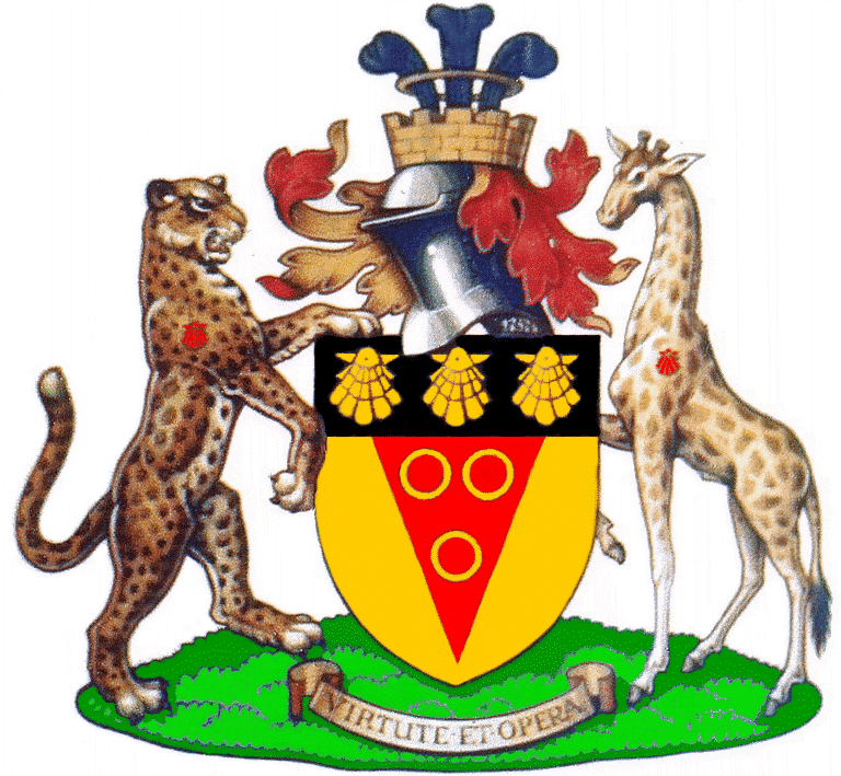
Arms granted by the College of Arms in 1912 and registered with the Bureau of Heraldry in 1994 (Government Gazette dated 29 April ’94):
Arms: Or, on a pile Gules, three annulets placed 2 and 1 Or; on a chief Sable, three escallops Or.
Crest: Issuant from a mural crown Or, masoned Sable, a plume of three ostrich feathers Sable, embellished Argent, enfiled of an annulet Or.
Mantling: Gules and Or.
Supporters: Dexter a leopard and sinister a giraffe, proper, each charged on the shoulder with an escallop Gules.
Motto: Virtute et Opera.
Link between 1912 and 1862 arms:
These arms (in the drawing the supporters and shield stand on a grassy ground) replaced the arms originally devised for the Grahamstown Municipal Council. The town (technically a city, since it has been an Anglican episcopal see since 1853)[1] was incorporated as a municipality in 1862. One of the council’s first acts was to appoint a sub-committee to draw up a coat of arms, which was adopted in September that year by the council.
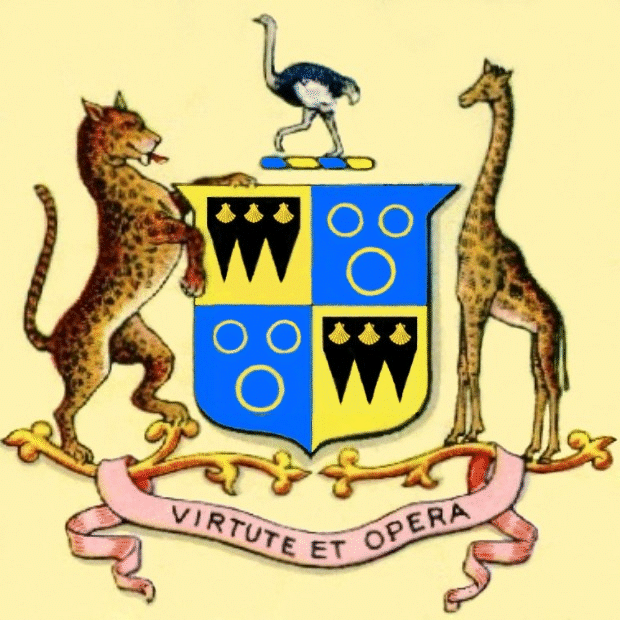
These arms may be blazoned:
Arms: Quarterly: I and IV: or, three piles sable; upon a chief sable, three escallops or; II and III: azure, three annulets or, 2 and 1.
Crest: An ostrich courant proper.
Supporters: Dexter, a leopard rampant; sinister a giraffe statant, both proper.
Motto: Virtute et Opera.
1862 arms explained:
The first and fourth quarters are a simplification of the arms of the town’s founder, Col John Graham of Fintry. The second and third are the arms of Jan van Riebeeck, first Commander of the Cape of Good Hope Colony (or, to be more accurate, those of his son Abraham). These arms were granted (with an anchor as supporter) to the Raad der Gemeente Kaapstad (Cape Town Community Council) in 1804, and the three annulets were later incorporated into the arms of the Cape Colony. The presence of Van Riebeeck’s annulets symbolises Grahamstown as part of the colony.
In Grahamstown’s case (in the 1862 arms) both family coats of arms are altered. In the arms of Graham of Fintry, the chief is couped (cut back so that there is a gold border on which the royal tressure stands). In the first and fourth quarters of the 1862 version the chief is still couped, even though the tressure has been dropped (since the city had not been granted this special royal honour). And in the arms of Van Riebeeck not only is the background colour altered, but the third (bottom) annulet is larger than the other two.
In the 1912 arms the Graham and Van Riebeeck elements are combined by placing the annulets on a single pile, now coloured red. The chief is no longer couped, but fills the top of the shield, but in other respects is unaltered.
The leopard (Leo pardus) and giraffe (Giraffa camelopardalis) represent wildlife once common in the Albany (Grahamstown) district (see arms of Albany Divisional Council) and seen as symbolising the wildness of the area when the British settlers first arrived in 1820.
The ostrich (Struthio camelus) was also a frequently seen part of the area’s fauna, and became commercially significant in the second half of the 19th century. In the grant of 1912 the ostrich became three ostrich feathers. These are wing plumes, which in nature only occur as pure white (on male birds) or white with narrow black stripes (on females). A black wing plume is one that has been dyed, and can be seen as a symbol of the ostrich feather industry. (For more information on this industry, see
Oudtshoorn.)
The motto, meaning “Courage and toil” is that of the Earl of Fife (since 1900 the earldom has been accompanied by a dukedom, held by the same person). Since English heraldry pays little attention to mottoes and does not regard them as needing to be unique to any particular person, there could be no objection to its adoption. The wording was seen as referring to the life of the early settlers.
These early arms were adopted by the two Government schools which became Graeme College and Victoria Girls’ High School, both of which have made certain changes. Both schools have, however, retained the larger third annulet of the 1862 arms. The Graham arms also appear in the arms of the Hoërskool P J Olivier, but in this case the device is not directly derived from the municipal arms.
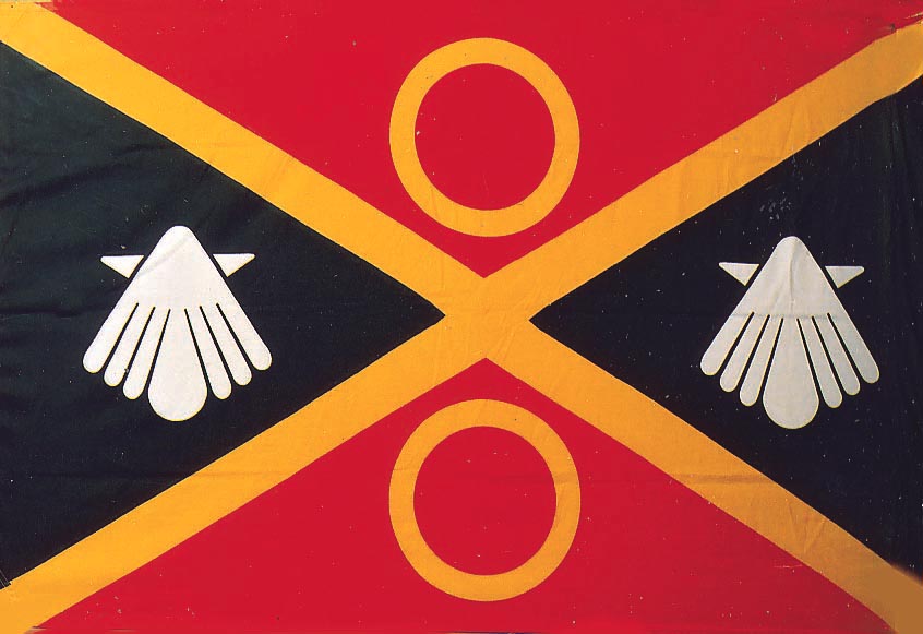
Municipal flag:
In March 1984 the City of Grahamstown adopted a flag, one of six designs prepared by heraldic expert Prof Hugh Smith, of Rhodes University. Ten years later it was registered and was gazetted on the same day (in 1994) as the coat of arms. It is described in the gazette as:
A rectangular flag in the proportion 2:3, per saltire red and black, charged with a saltire between above and below an annulet, all yellow, and in the hoist and the fly a white escallop.
History of Grahamstown:
Grahamstown traces its history to 1812, when Col Graham, of the Cape Regiment, having cleared the Zuurveld of amaXhosa, decided to use this particular valley, lying at the head of the Bloukrans River (a tributary of the Kowie River), as the central point of control for the line of forts that had been built along the Fish River.
He chose an abandoned farmhouse as the centre of his new settlement, and the officers of his unit laid out their tents in line with it. Houses were later built on the sites of the tents, and although this row of plots was out of alignment with the plots that were later laid out along what is now High Street, the officers refused to accept a realignment; this first row of plots became the angled part of Church Square. During the annual National Festival of the Arts, held in Grahamstown each July since 1974, the open space created by this “misalignment” becomes one of the busiest parts of the town.
In 1812 the Zuurveld was proclaimed a sub-drostdij of Uitenhage and Captain G S Fraser, assistant landdrost of Uitenhage, was stationed at Col Graham’s new settlement, following which the settlement was called Graham’s Town. In 1814 the Zuurveld was declared a separate district named Albany.
On 22 April 1819 Grahamstown was the scene of the biggest battle yet fought there when the largest Xhosa army ever assembled – at least 10 000 men – attacked at dawn. They had been told by the Xhosa prophet Makhanda, usually known as Nxele, that his muti (magic potion) would render them impervious to bullets. Nxele personally commanded part of the horde. Defending the village was a garrison of just 232 soldiers with a mere five cannon, fortuitously aided by a 130-strong party of Khoikhoi buffalo hunters who had arrived from Theopolis, the London Missionary Society mission station in Lower Albany. Just 2½ hours after the attack began, the Xhosa broke and fled, leaving about a thousand dead and only three British dead and five wounded.
Only monuments and two placenames remind us today of the Battle of Grahamstown: the Xhosa name for the town proper, eGazini (place of blood), and the hill overlooking the town from the east, Makana’s Kop.
In 1820 the Governor, Lord Charles Somerset, arranged that Grahamstown would be the administrative centre of the settlement scheme which was to see about 5 000 British settlers (English, Welsh and Scottish) taken by sea to Algoa Bay. Most of them were placed in agricultural settlements in the Albany district, although a few received allotments close to Port Elizabeth. A party of Irish settlers was first placed at Clanwilliam in the Western Cape, but they were later permitted to settle in the Eastern Province.
All these settlers together are remembered as the 1820 Settlers.
However, Lord Charles then left for long leave in England, and placed Sir Rufane Donkin in charge as Acting Governor. Donkin’s inspection of the area of settlement led him to move the landdrost’s seat to Bathurst, and work was started on a drostdij. However, when Lord Charles returned in 1821 he was furious with Sir Rufane for changing his arrangements and the landdrost was moved back to Grahamstown.
Its status assured through being a military and administrative headquarters, Grahamstown also became a centre for trades and professions. The Cape Parliament sat there once, in 1864 (the only time it sat anywhere but in Cape Town).
Grahamstown was the principal centre – but by no means the only one – of the Eastern Province separatist movement, and the 1864 session of Parliament was its solitary success. But the movement lacked cohesion, and divisions between the various eastern towns meant that it failed to bring about the establishment of a separate colony, free of Cape Town’s domination.
Also in 1864 Grahamstown became the seat of the Eastern Districts Court, which in 1910 became the Eastern Districts Local Division of the Supreme Court of South Africa, and in 1957 a Provincial Division of the Supreme Court. The Supreme Court was in 1995 renamed the High Court of South Africa, and although the Eastern Cape by now had three other local divisions, Grahamstown retained its status as the seat of the Provincial Division of the High Court. The city also became an educational centre.
The coming of the railways, linking the ports with first the Kimberley diamond fields and then the Witwatersrand goldfields, spelt the end of the predominance of inland towns in the Eastern Cape. This was especially the case with Grahamstown because it could only be reached by a tortuous branch line, and Port Alfred (to which it was also connected) never became prosperous like Port Elizabeth and East London.
In the 20th century Grahamstown has been hamstrung by a lack of industry and a large black population including many indigent people. Aside from education and the courts its chief employer has been the military: during the Second World War a flying training school was established on a plateau north of the town, which in the late 1960s was developed into a major infantry training base.
Following the local government elections of 2000, Grahamstown was joined with Alicedale and Riebeeck East into the Makana Local Municipality, part of the Cacadu District Municipality.
Names of the town:
The name Rini is now the usual Xhosa name for Grahamstown. However, during the apartheid years it was used officially as the name of the municipality created to administer the black townships which had previously fallen under the administration of the Grahamstown Municipality. Moves were being made to adopt arms for the Rini Municipality when in 1995 that structure was re-amalgamated with Grahamstown.
Strictly speaking Rini should be spelt “Rhini”, since the first sound is that of Afrikaans or Dutch G or Scots CH.
[1] Grahamstown was the seat of a bishop before 1853, since the first Roman Catholic bishop of Grahamstown was consecrated in 1847. However, because the Roman Catholic Church had no official status in the Cape Colony and the Anglican Church at that time shared the status of State Church with the Nederduitsche Gereformeerde Kerk, city status was recognised only from 1853. The Roman Catholic bishop’s seat was moved in 1939 to Port Elizabeth. Grahamstown is still known as a cathedral city, even though the concept of a State Church in the Cape Colony disappeared in the 1860s.

Vir Afrikaans, kliek hier
Comments, queries: Mike Oettle