PIETERMARITZBURG / UMGUNGUNDLOVU
Province/state: KwaZulu-Natal (previously Natal Province/Natal Colony/Republiek Natalia).
Additions: Msunduzi, 1995.
Incorporated: into uMngeni Municipality, 2000, part of UMgungundlovu District Municipality.
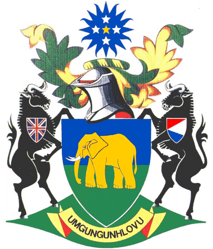
The arms as they appear here seem to have been registered with the Bureau of Heraldry under the Heraldry Act of 1962. They may be blazoned:
Arms: Per fess azure and vert, an elephant statant or, tusked argent.
Wreath and mantling: Or and vert.
Crest: A sun azure charged with five mullets, 1, 3 and 1, the centre mullet or, the rest argent.
Compartment and supporters: Upon a grassy mound vert, two wildebeeste sable, the dexter beast charged upon the shoulder with an escutcheon of the British Union; the sinister beast charged upon the shoulder with an escutcheon of the flag of the Republiek Natalia.
Motto: Umgungunhlovu.
About the arms:
The elephant and the sun charged with its cross of mullets (or five-pointed stars) have formed part of the symbolism of Pietermaritzburg since 1854, when the village was elevated to the status of borough.
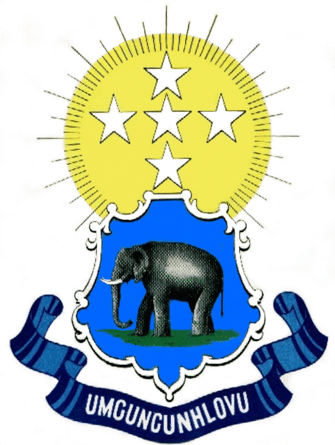
The illustration at right shows the arms as they were apparently borne from 1854 onwards:
Arms: Azure, an elephant statant proper.
Crest: A sun or, charged with five mullets argent, 1, 3 and 1, fimbriated sable.
Motto: Umgungunhlovu.
The elephant – an African elephant, Loxodonta africana – is a symbol of royal authority, and was deliberately chosen, together with the motto (meaning “place of the elephant”), to symbolise the shift of power from the kraal of the Zulu king – the kraal of Dingane (which lay entirely outside the colony as it then existed, north of the Thukela River and not far from the site of Ulundi, built in the 1970s and ’80s as the capital of KwaZulu) was called Mgungundlovu – to the residence of the Lieutenant-Governor (later Governor) of Natal.
In the final version of the arms the elephant’s colour is changed from grey (“proper”) to gold, to enable adequate heraldic contrast. Its background, instead of being plain blue (with an intrusive bit of green grass at the elephant’s feet), is now blue above and green below.
The sun in the crest has become blue – a strange choice, yet attractive nonetheless. It would now appear to represent the firmament, rather than merely the sun of our solar system. This allows the mullets to be rendered in metallic colours.
The wildebeeste are taken from the arms of Natal – see here for a discussion of their significance.
The escutcheons on their shoulders bear the contents of the flags – rather than the arms – of first the Republiek Natalia (1838-42) and then the British Empire (the Union Jack).
The Natalia device reflects the flag as it is popularly thought to have been flown, although recent research indicates that what was thought to be the hoist of the flag was in fact the fly.
The Union Jack can be traced back to the joining of the crosses of St Andrew and St George as the symbol of Britain following the union of England and Scotland, although its current form dates from 1801, when Ireland became part of the United Kingdom. It was flown officially in Natal from the annexation in 1842
until South Africa became a republic in 1961.
In Natal the white population was far more attached to the Union Jack than in the rest of South Africa, and between 1928 and ’61 it was almost invariably flown side by side with the South African Union Flag, not only by the corporations of Pietermaritzburg and Durban, but also by the Natal Provincial Administration and even Natal Command in Durban, the regional military headquarters.
Elsewhere in South Africa the Union Jack and its ancillary flags were little seen after 1928, and more especially after 1952, when the South African Red Ensign also ceased to be the country’s merchant flag.
About the city:
Voortrekkers founded a village in the upper valley of the Msunduzi River on 23 October 1838 and named it Pietermaritzburg, after the Trek leaders Pieter (Piet) Retief and Gert Maritz, both of whom had died before the Trekkers had been able to establish their state in Natal.
The layout of the village, located on the Boesmansrand, between the Dorpspruit and the main stream of the Msunduzi (known then as Umsindusi), was entrusted to Commandant Piet Greyling.
This event preceded the proclamation of the Republiek Natalia.
One of the first decisions of the republic’s Volksraad concerned the survey of the town (which from the start was the capital of the fledgling state) and its administration; this was embodied in a proclamation of 15 February 1839.
The original township was a parallelogram roughly 2 km by 1½ km with a market square in the centre. Water from the Dorpspruit was diverted to provide irrigation for all the erven (plots). The furrows along which the water was channelled have long since disappeared, but for much of the 19th century were characteristic of the town.
The settlement remained a laager until 1840, when Dingane’s power was finally broken. In that year a Raadzaal (a chamber for the Volksraad), a jail, a powder magazine and a church (now known as the Church of the Vow) were built.
The town’s first
landdrost, Jacobus Nicolaas Boshoff, was appointed in February 1841. (The office of landdrost fell away under British rule.) Boshoff would later serve as president of the Oranje Vrij Staat.
Following the British annexation of 1842, the Volksraad submitted to British authority and a British garrison was established on the hill at southern end of the town. Named Fort Napier, this became an important military centre.
An entry in the Standard Encyclopædia of Southern Africa records:
“The town grew steadily and the first Natal newspaper, Die Natalier, established in 1844, was able to report that there were 132 brick or stone dwellings. The year 1849/50 saw an influx of new inhabitants as a result of the Byrne immigration scheme, by
which Natal gained some 2 000 people from Britain and Germany. By 1852 the population of Pietermaritzburg was 2 400, of which 1 508 were Whites.”
The oldest newspaper still continuously published in South Africa, the Natal Witness, first appeared in Pietermaritzburg in 1846.
The town was proclaimed a borough in 1854, with D D Buchanan as first mayor. In that year the town also adopted its first coat of arms (referred to above).
The city’s principal State hospital, Grey’s Hospital, was first built in 1855, and named after the Governor of the Cape (and of Natal), Sir George Grey.
The town formally became the capital of the Crown Colony of Natal in 1857.
The Voortrekker Raadzaal, completed in 1842, was used as the Supreme Court of the colony from 1846 to ’71. The site is now occupied by the City Hall, first completed in 1893, but destroyed by fire in 1898 and rebuilt. It was formally opened, after restoration, on 14 August 1901 by the Duke of Cornwall and York (later King
George V). The building, reputed to be the largest all-brick structure in the world, is a national monument.
By 1880 Pietermaritzburg had been linked to Durban by a steam-operated railway line. It was to take another 13 years before the city was to be linked to Johannesburg by rail.
With the formation of the Union of South Africa in 1910, Pietermaritzburg was the only one of the four colonial capitals not to attain the status of a national capital. However, it remained the capital of what now became the Province of Natal, and additionally became the seat of the Natal Provincial Division of the Supreme Court of South Africa.
SESA does not state when Pietermaritzburg was elevated to city status. However, since Durban became a city in 1935, it cannot have been too distant in time from that date.
For many years Pietermaritzburg was known as “Sleepy Hollow”, since it had little industry. However, a new city council elected in the 1960s attracted industries to the vicinity, and although the city is no rival to Durban as an industrial and commercial centre, it manages to hold its own.
In 1994 Pietermaritzburg became one of two capitals of the Province of KwaZulu-Natal, the other being the KwaZulu legislative seat, Ulundi. However, in 2002 the provincial legislature resolved that Pietermaritzburg would be the province’s only capital.
Names of the city:
The city’s official name has remained Pietermaritzburg since its founding, although its pronunciation has been anglicised to Peter-marrits-buhg. However, in common parlance the name has frequently been reduced to Maritzburg. The Afrikaans pronunciation is characterised by rolled Rs, a short first syllable and stress especially on the second syllable of the name Maritz.
The city’s principal nickname, given to it by, among others, the Natal Witness, is “the Capital”.
The name Umgungunhlovu is a colonial form of Gingindlovu – the sound represented by the letters NDL is similar to (although phonologically distinct from) that of the letter-combination
NHL, and appears to have confused the colonists. The Nguni language of the colony had in in 1854 not yet been fully formalised in written form.
This name – its spelling corrected to Umgungundlovu – became an official name of the city in 1994, when isiZulu became one of South Africa’s official languages.
However, in the reorganisation of municipal government that came in 2000, the name UMgungundlovu was given to the district municipality for central Natal, of which the capital formed only a small part.
The city had already in 1995 been merged with its black townships, which had been called Msunduzi. In the 2000 dispensation, the smaller towns of Howick and Hilton were added to the city to form the uMngeni Municipality.

Vir Afrikaans, kliek hier
Sources: Illustration of modern arms from a postcard issued by the South African Post Office; 1854 arms from a scrapbook illustration at the Africana room of the
Port Elizabeth Central Library. Historical notes from the Standard Encyclopædia of Southern Africa (Nasou) and other sources.
Back to Armoria civica index
Back to Armoria index